Share this tour


Offered languages
- English
Why settle for one park when you can explore two? This combo features tours through Zion and Bryce Canyon, two incredible Utah parks that sit right next to one another! Witness natural wonders like Zion’s Temple of Sinawava and Bryce’s mysterious hoodoos. Stand atop incredible overlooks. Uncover the fascinating human history behind each park. Plus, if you’re in the mood, embark on breathtaking hikes you’ll never forget!
Purchase one tour per car, not per person.
After booking, check your email/text to download the separate Audio Tour Guide App by Action while connected to WiFi or mobile data. Enter the password, download the tour, and enjoy it offline. Follow the audio instructions and route from the designated starting point.
New, Lifetime access, no expiry. Use it anytime, on any trip, as many times as you want.
**March to late November: Driving on Zion scenic drive is prohibited. Use the audio stories on the shuttle bus. Driving is allowed when the Shuttle closes down.**
What's Included
Meeting and pickup
Itinerary
-
Bryce Canyon National Park (Pass by)
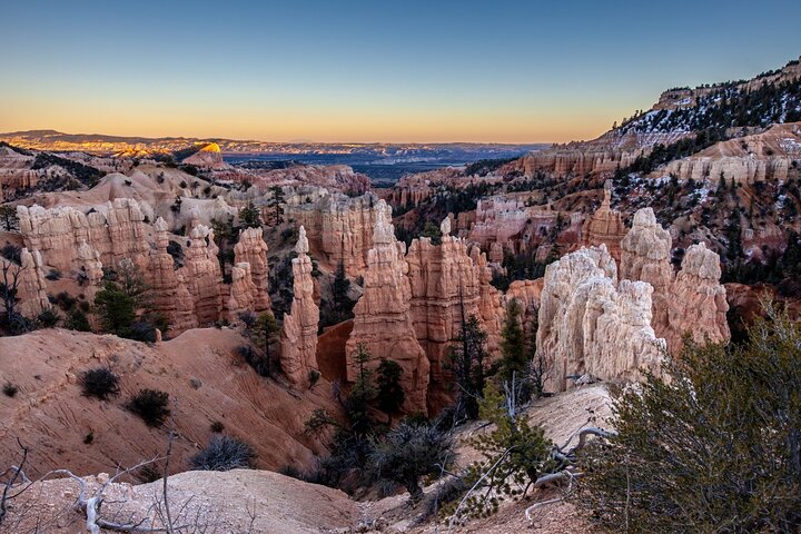
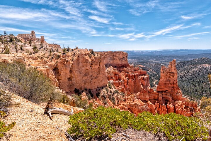
Named after the Mormon Pioneer Ebenezer Bryce, Bryce Canyon became a National Park in 1924. Bryce is famous for its unique geology, which consists of a series of horseshoe-shaped amphitheaters carved from the eastern edge of the Paunsaugunt Plateau in southern Utah. Named after the Mormon Pioneer Ebenezer Bryce, Bryce Canyon became a National Park in 1924. NOTE: The tour is over 20+ miles long per tour, with more than 50+ audio stories per tour, and takes about 2-3 hours per tour to complete. New, Lifetime access, no expiry. Use it anytime, on any trip, as many times as you want.
Admission ticket free -
1Bryce Canyon Visitor Center
Embark on this epic adventure through Bryce Canyon National Park just before the Visitor Center. As we begin the drive, we'll learn about how the canyon got its namesake and about the original Paitue people who called this land home.
2 hours • Admission ticket free -
2Fairyland Point
Our first detour is at the breathtaking Fairyland Point. This overlook offers a great sneak peek at everything Bryce Canyon contains: sweeping vistas, sheer cliffs, and, of course, the world-famous hoodoos!
30 minutes • Admission ticket free -
3Sunrise Point
Our next stop is one of the most famous in the entire park: Sunrise Point. From this vantage point, we'll see unique, picturesque rock formations spread out in front of us and a plethora of natural trails leading into the vast, alient landscape.
10 minutes • Admission ticket free -
4Bryce Amphitheater
Our self-guided driving tour continues around the famous Bryce Amphitheatre! The canyon curves around in the shape of a giant semicircle and dips far below our feet.
10 minutes • Admission ticket free -
5Sunset Point
Our drive brings us to another striking vista point overlooking the Bryce Amphitheatre: Sunset Point. Here, as we gaze out over the implausible shapes below us, we'll learn about the science behind their formations and understand what, exactly, makes a hoodoo. We'll explore the impact of geology and erosion over a monumental time scale, hoping to understand how such a incredible landscape came into existence.
10 minutes • Admission ticket free -
6Inspiration Point
We continue our self-guided tour deeper into Bryce Canyon, towards Inspiration Point. As we drive, we learn about the Paiute people and their mythologies. They had their own explanation for the uniqueness of this landscape and the origins of Bryce's famous hoodoos.
10 minutes • Admission ticket free -
7Bryce Point
This brings us to Bryce Point, which offers one of the most scenic vistas of the full amphitheater. Bryce Point is also famous for its extraordinary sunrises. From here you can watch the tops of hoodoos set alight as if by fire from the first rays of the rising sun. Like fire, the orange light quickly spreads driving shadows from all but the deepest recesses of the amphitheater. As we drive here, we'll learn about the Mormon settlers who followed the Paitue and tried to eke out a living in this unforgiving climate.
10 minutes • Admission ticket free -
8Paria View
Our self-guided tour continues to Paria View, where we see the effects of a centuries-old glacier. As the earth warmed about 12,000 years ago, the last ice age came to an end. As the enormous glaciers which covered the American continent melted, all that new water had to go somewhere. Answer: down the canyon!
5 minutes • Admission ticket free -
9Swamp Canyon Overlook
Now our drive takes us into the lesser-trafficked part of the park. As we drive to Swamp Canyon Overlook, we'll learn about a famous local: Butch Cassidy! We'll learn all about Butch, Sundance, and the difference between fact and fiction as we continue the self-guided tour.
10 minutes • Admission ticket free -
10Farview Point
Our next stop is at Farview Point. It’s not just the elevation that allows for such incredible views here -- the land here also offers something becoming increasingly rare in today’s world. Can you guess what it is? Clean air! That's helped along by the abundance of bristlecone pines here, which are the Earth's oldest trees.
5 minutes • Admission ticket free -
11Natural Bridge
The self-guided tour passes by Natural Bridge next, which features unusual arches and formations -- in case we weren't already amazed by the hoodoos of the amphitheatre!
10 minutes • Admission ticket free -
12Bryce Canyon Road
At Agua Canyon two prominent hoodoos command attention. On the left, is the taller of the two towers, "The Hunter." To the right, the "Rabbit". Neither look anything like a hunter or rabbit though! As we drive on, we'll learn about rabbits, deer, and other wildlife of Bryce. We'll also understand what tricks they use to survive the scorching hot summers and deeply freezing winters.
10 minutes • Admission ticket free -
13Ponderosa Canyon
This brings us to Ponderosa Point, from which you can see the park’s iconic junipers sprawling out into the distance. We're now driving into the deepest recesses of Bryce Canyon National Park.
10 minutes • Admission ticket free -
14Black Birch Canyon
Our self-guided drive continues towards Black Birch Canyon Overlook. As we drive, we'll learn all about the night sky and opportunities for amateaur astronomy while you're here. The stargazing at Bryce is unparalleled.
5 minutes • Admission ticket free -
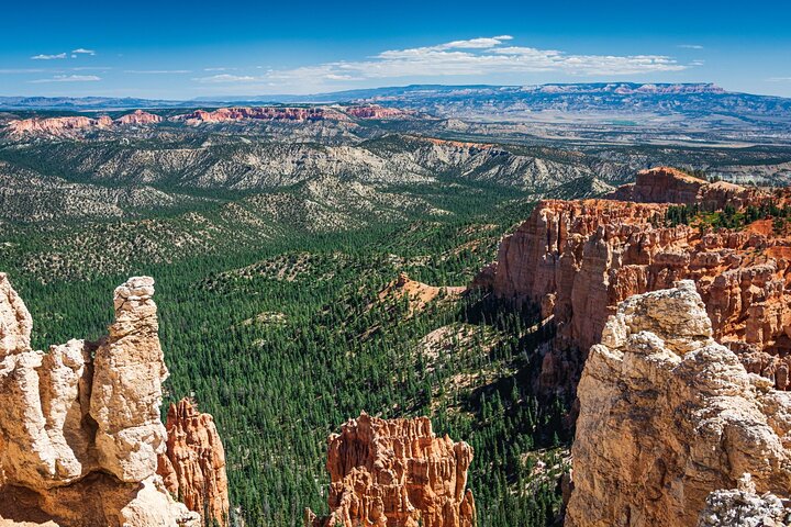
15Rainbow Point
Finally, we reach the farthest overlooks inside Bryce Canyon: Rainbow and Yovimpa. From here, you can see nearly everything in Bryce Canyon -- the quintessential hoodoos, the verdant basin, the sheer cliffs. You can even see that you're on the top step of the incredibly massive "Grand Staircase" -- a geologic structure "stepping down" all the way to the Grand Canyon in Arizona.
10 minutes • Admission ticket free -
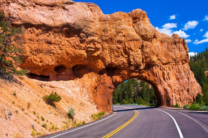
16Red Canyon
That arch up ahead and its twin a little ways down the road are the Red Canyon Arches. These might look a little like natural arches, but they’re actually made by people. Workers tunneled through solid rock here in 1914 to make room for the road. Since then, these have become a sort of gateway to the beautiful expanse of Bryce Canyon.
10 minutes • Admission ticket free -
Zion National Park (Pass by)
Zion National Park is a southwest Utah nature preserve distinguished by Zion Canyon’s steep red cliffs. Zion Canyon Scenic Drive cuts through its main section, leading to forest trails along the Virgin River. The river flows to the Emerald Pools, which have waterfalls and a hanging garden. Also along the river, partly through deep chasms, is Zion Narrows wading hike.
Admission ticket free -
Springdale Visitor Center (Pass by)
Welcome to Zion National Park! This raw landscape has it all: staggering mountain peaks, stunning natural pools, and gorgeous vistas. We’ll explore it all today.
Admission ticket free -
Zion Canyon Visitor Center (Pass by)
Continue straight. Just before the bridge, you’ll see a path on the left. That’s the start of the Pa’rus Trail. And just after the bridge is another path -- the Watchman Trail. Both are popular hikes with great views at the end.
Admission ticket free -
Zion Human History Museum (Pass by)
While we don’t know too much about those Ice Age hunters, newer residents left their stories behind. Around 300 BCE, people started settling down here and farming. They grew squash and corn, and gradually learned how to better cultivate the land and survive the unforgiving climate. One group, the Fremont, cultivated a drought- and cold-resistant species of corn which could thrive even at high altitudes.
Admission ticket free -
Canyon Junction Bridge (Pass by)
We’re almost at Canyon Junction Bridge. There’s a lot going on there: First, it’s a great sunset spot. Be sure to come back here later. Second, there are great views of the Watchman and other mountains. If you find parking, take it and listen to the Learn More stories about the peaks. Third, this is where the road splits: Turn left if you want to drive along the Scenic Road and visit the Narrows, Angel’s Landing, or the Emerald Pools.
Admission ticket free -
17Zion Canyon Scenic Drive
Whew, what a view! Those three mountains are the iconic Court of the Patriarchs. And who are these patriarchs? Well, a local Christian minister named them after three figures from the Bible: Abraham, Isaac, and Jacob, from left to right.
3 hours • Admission ticket free -
Zion National Park Lodge (Pass by)
The park service works hard to keep this place as natural and untouched as possible… while simultaneously handling over 4 million visitors each year. But that wasn’t the case in the early 1900s. No one knew about this place and that meant no revenue... and that meant… development.
Admission ticket free -
Emerald Pools (Pass by)
First, bring lots of water! You may think you’ve got enough… but you probably don’t. This might seem obvious, but Utah’s heat is unforgiving, and heat-stroke or sun-stroke can easily ruin a fun vacation. Second, make sure you don’t overtax yourself! Hiking around here is going to be more difficult than you might be used to, thanks to the elevation. Be sure you don’t embark on journeys you’re not certain you’ll be able to finish.
Admission ticket free -
Angel's Landing (Pass by)
This park has a ton of great trails, but Angel’s Landing stands in a league of its own. Those who complete the hike describe it as a breathtaking experience like no other, offering impossible views and a major adrenaline rush.
Admission ticket free -
The Grotto Picnic Area (Pass by)
his spot offers picnic tables, restrooms, and fire grates. But the surrounding trails are the main attraction!
Admission ticket free -
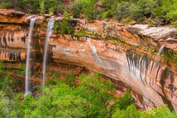
Weeping Rock Trail (Pass by)
A continuous stream of water trickles down its face from a stream far above
Admission ticket free -
Big Bend Viewpoint (Pass by)
As we round the Big Bend of the Virgin River, we’ll approach the last viewpoint on this drive. Stop there for magnificent views of the Great White Throne and the towering peak of Angel’s Landing.
Admission ticket free -
Temple of Sinawava (Pass by)
To see the Narrows, you’ll want to follow the paved Riverwalk all the way to the end. It’s a flat, easy walk, full of beautiful greenery and towering natural skyscrapers. But before you set off, let’s talk about the Temple of Sinawava.
Admission ticket free -
18The East Temple
That towering summit ahead is the East Temple, standing at 1,700 feet. Notice how the cliff isn’t all one color? You’ve probably seen this on the other rock faces as well. That’s because these cliffs are actually made of rock from a bunch of different eras in the earth’s history.
5 minutes • Admission ticket free -
Zion scenic drive viewpoint 2 (Pass by)
At the next hairpin turn, you’ll see a pull off. If there’s room, stop there for some incredible views. While stopped, click on Learn More to hear why the Mormons called this place Zion.
Admission ticket free -
19The Zion-Mount Carmel Tunnel
Make sure to turn on those headlights -- because the Zion-Mount Carmel Tunnel is just ahead! Once inside, you might be tempted to stop and take photos, but you’ll have to resist the urge: stopping is strictly prohibited.
5 minutes • Admission ticket free -
Canyon Overlook Trail (Pass by)
The Canyon Overlook Trail is one of East Zion’s finest -- even though it’s short and easy. Why? Simple -- the spectacular views from the top.
Admission ticket free -
20Altar of Sacrifice
If you look closely at the Altar of Sacrifice, you’ll notice that it’s got streaks of rusty red running down the sides. Early Mormon pioneers saw this and thought it looked like blood spilling from a sacrificial altar. Of course, there’s a much less gruesome explanation.
1 hour • Admission ticket free -
Checkerboard Mesa (Pass by)
Look at that mesa rising into the sky. Notice anything peculiar? As you get closer, you should be able to make out a strange grid of criss-crossed lines all over it. It looks a bit like a checkerboard, which is how it gets the name Checkerboard Mesa!
Admission ticket free -
East Entrance Ranger Station (Pass by)
We’re at the East Ranger Station, which means we’ve reached the end of our tour. I hope you’ve enjoyed learning about the formation of this majestic place and all the people who’ve lived here over the millennia. If you’re planning to visit other parks in the southwest, such as Bryce, Arches, or Monument Valley, be sure to check out my other tours.
Admission ticket free
Additional info
- Public transportation options are available nearby
- Suitable for all physical fitness levels
- How To Access: After booking, you’ll get an email and text with setup instructions and password (search “audio tour” in emails and texts). • Download the separate tour app by Action • Enter the password sent by email and text. • MUST download the tour while in strong wifi/cellular. • Works offline after download.
- How to start touring: Open Action’s separate audio tour guide app once onsite. • If there is just one tour, launch it. • If multiple tour versions exist, launch the one with your planned starting point and direction.
- Go to the starting point No one will meet you at the start. This tour is self-guided Enter the first story’s point and the audio will begin automatically Follow the audio cues to the next story, which will also play automatically. Enjoy hands-free exploring. If you face audio issues, contact support. Stick to the tour route & speed limit for the best experience.
- Savings tips: Driving tours: purchase just one tour for everyone in the car
- New, Lifetime access, no expiry. Use it anytime, on any trip, as many times as you want.
- Audio Setup: Connect your phone to your car's stereo system using Bluetooth, USB, or AUX. For the best experience, consider using headphones for walking tours. Audio playback is compatible with Apple CarPlay, with navigation features coming soon. Support for Android Auto is also on the way.
- The tour requires a supported mobile device for navigation. Please use an iPhone with iOS 15 or later, an Android device with Android 9 or later, or an iPad/tablet with GPS and cellular service.
- Zion Important Note: Angels Landing will be closed for maintenance from April 20–23, 2026. No permits will be issued during this time. The West Rim Trail remains open. The day-before lottery reopens on April 23 for hikes on April 24.
- Travel worry-free: Use the tour app anytime, on any day, and over multiple days. Start and pause the tour whenever you like, taking breaks and exploring side excursions at your own pace. Skip anything you don’t care about or explore bonus content for everything that interests you
Tags
Cancellation Policy
For a full refund, cancel at least 24 hours before the scheduled departure time.
Cancellation Policy
- For a full refund, you must cancel at least 24 hours before the experience’s start time.
- If you cancel less than 24 hours before the experience’s start time, the amount you paid will not be refunded.
- Any changes made less than 24 hours before the experience’s start time will not be accepted.
Rating
You can cancel up to 24 hours in advance of the experience for a full refund.
Your guide to the flawless travel experience